Well, my Chinese is slowly getting better. I was able to order coffee and green tea at Starbucks last weekend (yeah, I know, the irony). However, when the clerk started asking me details like how large and how much sugar I was back to pointing or replying in Chinglish. One problem with speaking Chinese is that people assume that you speak it very well. Or, perhaps, my pronunciation is very good but I doubt it. I have also noticed that when I try to speak Chinese slowly and carefully people get confused, but when I speak normally, and without much thought of the tones, people understand me. For me, the tones and logographic characters (versus a phonetic alphabet) are the most difficult part of Chinese. What I am learning, Bopomofo
http://en.wikipedia.org/wiki/Bopomofo, is a phonetic system for writing Chinese but it is only used in Taiwan and it is only used for teaching children Mandarin in Taiwan. You won't see signs written in Bopomofo. Most people start with Pinyin as it is more widely used, but Bopomofo uses "Chinese" looking letters to represent each phoneme. It is my hope that my brain will have an easier time recognizing Chinese characters by learning Bopomofo instead of Pinyin.
http://en.wikipedia.org/wiki/Pinyin
The problem with Pinyin is that it is not standardized. So, Xitun Road may also be spelled Situn Road, for example. It was all quite confusing when I first came to Taiwan, but I'm starting to get the hang of it.
If you want to learn Bopomofo look at this. It's a very cute You-Tube video my teacher sent to me.
I sit with some teachers at lunch. Sometimes, I am able to hear words I know. I showed them some of my homework and handouts for my class. They were very impressed with the hand-outs that my tutor makes. One teacher said, "Your teacher is very good. Don't let her go." Way to go Anshing! She IS a very good teacher. Wendy (Anshing) is my friend. We were friends before she became my Chinese tutor. Like so many friends today we are 'talk' on Facebook. Sometimes, I am afraid to go on Facebook because I'm afraid she will be online. She'll ask me, "Have you done your homework?" or "Have you been studying Chinese?" She doesn't say, "Hello, how are you?" she goes straight to Chinese. And, she usually asks me in Romanized Chinese too. So, "Hello, how are you?" becomes "Ni hao, ni hao ma? http://en.wikipedia.org/wiki/Romanization_of_Mandarin_Chinese
English to Chinese and Chinese to English...it all gets very confusing. However, in general, Chinese seems to be very logical. For example, for days of the week you say, day-one (Monday), day-two (Tuesday), day-three (Wednesday)...or shing-chee e, shing-chee er, shing-chee san. The word for 'things' is dongshi which translates as 'east to west' or everything-under-the-sun. A computer is an 'electric brain'.
Tuesday, March 1, 2011


Desyueshan National Forest Recreation Area
It's was a three day weekend. Monday was Peace Day in Taiwan. Peace Day, http://en.wikipedia.org/wiki/228_Incident, recognizes the 228 Incident. I won't get into the history of the holiday, but it does have political ramifications to this day.
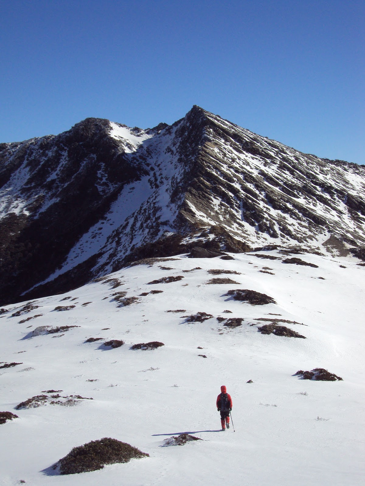
I went hiking for a day in Desyueshan National Forest http://www.taiwan-travel-experience.com/dasyueshan.html. The trail was not very long, but it was quite rugged and steep. It's also great to get away from the city noise and pollution. The national park is about a two hour drive from Taichung. Since it was a holiday weekend there were many people on the trail. I was very surprised to see the very young and the very old on this trail. When you look at my pictures you will understand. We hiked the Yuanzueishan-Shaolaishan trail. Yuanzueishan Mountain (Eagle Mountain) is pictured below. The trial follows the steep ridge of the mountain and some sections are 'technical' class 5 climbing. Lots of fun for a monkey boy like me.
Yuanzueishan Mountain (Eagle Mountain) is about 2300 (7,545 feet) meters high. Taiwan has the highest number and density of high mountains in the world.

 Yeah, this is as steep as it looks.
 Some hikers on the ridge of the mountain.


I went hiking for a day in Desyueshan National Forest http://www.taiwan-travel-experience.com/dasyueshan.html. The trail was not very long, but it was quite rugged and steep. It's also great to get away from the city noise and pollution. The national park is about a two hour drive from Taichung. Since it was a holiday weekend there were many people on the trail. I was very surprised to see the very young and the very old on this trail. When you look at my pictures you will understand. We hiked the Yuanzueishan-Shaolaishan trail. Yuanzueishan Mountain (Eagle Mountain) is pictured below. The trial follows the steep ridge of the mountain and some sections are 'technical' class 5 climbing. Lots of fun for a monkey boy like me.
Yuanzueishan Mountain (Eagle Mountain) is about 2300 (7,545 feet) meters high. Taiwan has the highest number and density of high mountains in the world.


In The Newspaper
There was a calligraphy class at Chun-An Elementary school a few months ago. A picture of me ended up in the local newspaper. One of my students at Hui-Lai Elementary school cut out the article and made a card for me.
 This is the front of the car.
 This is the back of the card.


Tuesday, February 1, 2011
Mountain Withdrawal
I've been experiencing mountain high withdrawal since coming back to Taichung. Getting out of the city has made me more sensitive to the smells and noises of the city. I can smell the air pollution quite vividly and sometimes I think I can taste it. The noise pollution seems more raucous than before and my patience for traffic and dangerous driving is much less. I would experience these sensations very strongly in Denver after months of guiding in Utah, but the air and noise pollution is much worse in Taichung so just a few days in the high mountains puts these qualities in perspective. I am also aware of the stress it puts on my body as I could feel muscles tensing in my neck and shoulders as my guide drove me to my apartment in Taichung. It's a good lesson for me and shows me how our perspective becomes dulled by regular sensations.
Sunday, January 30, 2011
Winter Ascent of Nanhu Mountain
Wo pah luh Nanhu Shan. I climbed Nanhu Mountain. It was a four day hike that covered about 55 kilometers and took me to the summit of four mountains. The mountains are very steep and rugged in Taiwan so I estimate that we climbed about 5000 vertical meters or about 16,000 feet.

This is the sunrise on our first day a few kilometers into the trip. We will be waking up at 5:30 AM for the next four days to make the most of the day light.
 This is Syue or Snow Mountain. I climbed it last winter. There are pictures on this blog.

 Snow Mountain to the left with the Sacred Ridge running to the right side of the frame. The Sacred Ridge is a difficult and technical route that will "turn boys into men and girls into women." I hope to climb it someday.
 There are several National Parks in Taiwan. Nanhu Mountain is located in Taroko National Park. Taroko National Park is know for the steep river gorges that lead to the Phillipine Sea on the east side of Taiwan, but it is also home to many spectacular mountains like Nanhu.
 Another shot of Snow Mountain and the Sacred Ridge.
 The sea of clouds that is quite common in Taiwan. The proximity of the ocean makes this sight common from my climbing experience in Taiwan.
 That is Nanhu Main Peak on the right side of the frame, but, like most mountain hiking, the direct route is not always easier or even possible. We will follow that undulating ridge to the left of Nanhu before we drop about 1000 feet to the cabin at the base of the mountain. Of course, we will have to climb out of that basin and back along that ridge to get back to the van (after climbing Nanhu Main and Nanhu East Peaks...a very long and strenuous day).
 A minor peak on our first day and on our way to the first cabin. I'm not sure if it has a name, but it had a number. We climbed about 1000 meters (or 3000 feet) at this point.
 The first cabin about 12 kilometers and 1000 meters into the hike.
 The next morning starts with a steep and arduous climb through the forest up to the ridge that will lead us to Nanhu Basin. Yes, this is the trail through the forest.
 Ah, out of the forest and making our way up to the ridge where the hiking will turn to climbing and things will start to get exciting.
 The ridge leading to Nanhu Basin. That is Nanhu Main Peak on the left.
 This is where things get exciting. We have put on our crampons (bing zhou) and there are some fixed ropes, but there are moments of exposure that require focus and fortitude.
 There are strong winds blowing over the top of Nanhu and the ridge that are making clouds that trail off to the north-west.
 This is a steeper section of the ridge with some fixed ropes
 I am a very happy climber.
 The sun was making rainbows in the clouds trailing off the ridge. The clouds were so close and thick you could see our shadows on them. Our heads were shrouded with small rainbow halos. It was amazingly beautiful!

 That is Nanhu Basin. You can see our cabin down in the valley. Tomorrow morning we will hike up the broad gully in the middle of the picture and then take a left to follow the ridge of Nanhu up to the summit.
 On our way up the gully with the sunrise and the moon over Nanhu Shan.
 Starting our climb up to the ridge of Nanhu with the sea of clouds roiling below us.


 This was the crux near the summit of Nanhu Main Peak. It was a short technical section with a lot of exposure. If you slip and fall the wrong way you're tumbling down the mountain.
 That's the ridge we came across yesterday (and we'll hike back over it after lunch today). We've come a long way.
 On the summit of Nanhu Main Peak at 3742 meters or 12,276 feet. I've been living close to sea level for almost a year and half so the air feels quite thin. Even when I lived in Colorado I would notice the effects of high altitude. I had trouble sleeping the night before our ascent which is quite common when people ascend to high altitudes.
 My climbing partners on the summit of Nanhu Main Peak.
 That long 'wedge' is Nanhu East Peak. The guide and I will do a quick ascent of it next.


 A mountaineers main tool are crampons or bing zhou.
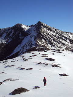 Heading for Nanhu East Peak. We will follow a narrow shelf to the right and then make a hard left and follow a broad couloir up to the summit. I will use my ice axe for this ascent.
 The broad couloir up the the summit of Nanhu East Peak. It's not too steep and the exposure isn't bad either, but I'm still using my ice axe.

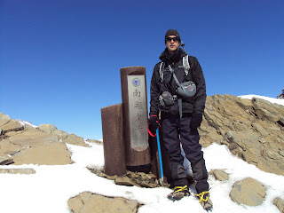 On the summit of Nanhu East Peak
 My guide on near the summit of Nanhu East Peak with Nanhu Main Peak.
 Nanhu Main Peak from the summit of Nanhu East Peak
 The high cabin in the Nanhu Basin
A short video from the rugged ridge leading to Nanhu Basin. You can really get a sense of how the sea of clouds can surround you in the high mountains of Taiwan. It really makes you feel like you're on top of the world.
A short video from the summit of Nanhu East Peak.

This is the sunrise on our first day a few kilometers into the trip. We will be waking up at 5:30 AM for the next four days to make the most of the day light.


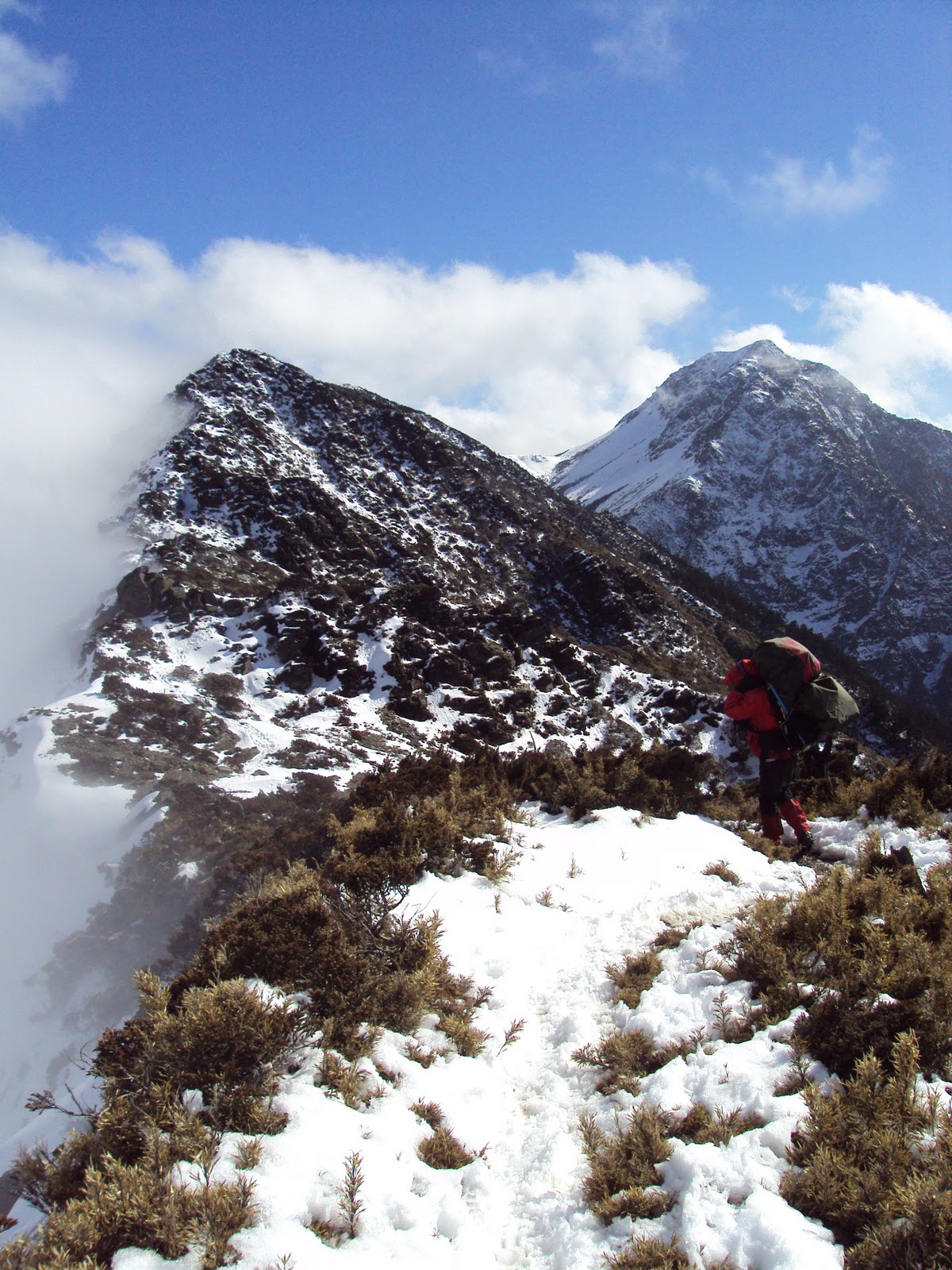

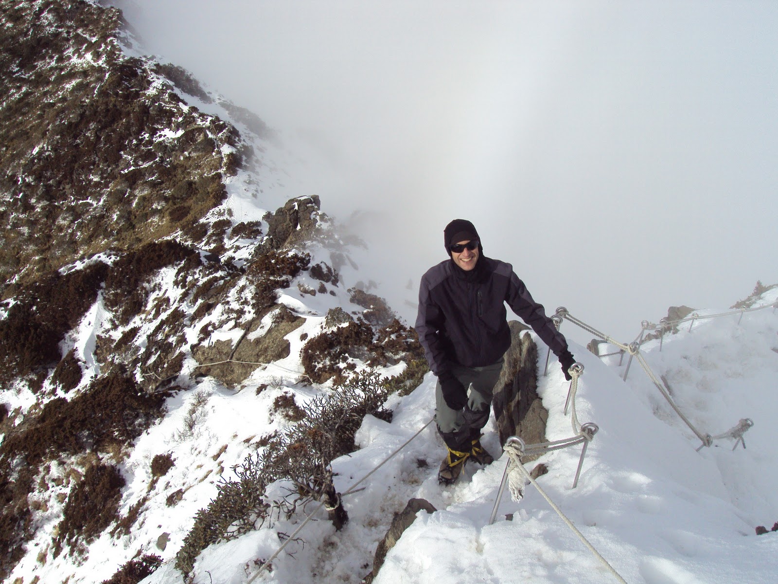




A short video from the rugged ridge leading to Nanhu Basin. You can really get a sense of how the sea of clouds can surround you in the high mountains of Taiwan. It really makes you feel like you're on top of the world.
A short video from the summit of Nanhu East Peak.
Wednesday, December 29, 2010
Calligraphy Class At Chun-An
We had a calligraphy class at Chun-An this afternoon. I drew about half of the class with my right hand because I thought it was the proper way to do it. When I asked the teacher if it was okay to use my left hand she was surprised. She thought I was doing well with my right hand. It is a lot harder than it looks. Creating the correct proportions is difficult enough, but it also requires a steady and even stroke to create a good line.
I drew these with my left hand.

This is the one I drew with my right hand before I realized it was okay to use my left.

I drew these with my left hand.

This is the one I drew with my right hand before I realized it was okay to use my left.

Subscribe to:
Posts (Atom)